
A tool to handle Satellite images updates: new "Map Shift"
A tool to handle Satellite images updates: "Map Shift"
For those who don't know what is this about - a short introduction: every month or so Google updates their satellite imagery and sometimes as a result of it this outline positions of Wikimapia objects in some areas become out of sync. This is an example of how it may look like: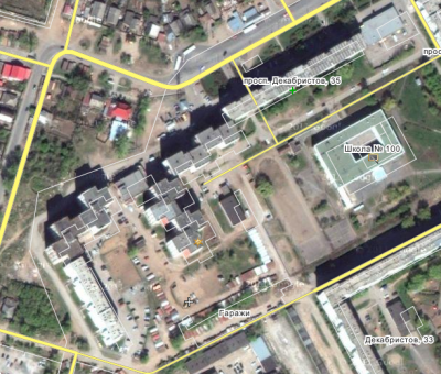
Such areas need to be fixed. To avoid doing this for each object individually, we have designed a special tool, which allows simply to update the whole areas, where this problem occurs.
You may be familiar with it, it is called "Map shift" and is accessible from the user tools page in the top menu or user profile page and via direct link: http://wikimapia.org/#m=b&show=/user/to ... /status=0/ .
Now we are releasing a new version of it and making it available to more users than before.
How it works:
The tool provides a list of areas, where the satellite imagery was updated. Most of the outlines of these areas are imported automatically from the data published by Google, so naturally not all of them have actual problems, some imagery updates are fitting perfectly well . There are also problematic areas in this list that are spotted and marked by our users. Every area in the list needs to be verified by several users in order to fix it or leave it as it is. If the outlined area has a visible gap between Wikimapia objects and satellite photography in it, you can set a direction and distance of shift required to put them back together. If not, you can confirm it by simply pressing a button. You can also add an area yourself, if you are sure it is not contained by any other listed there.
After the area has been verified by sufficient number of users, system automatically calculates the average values and some statistics and decides whether objects in the area should be updated and how.
Unlike the two previous versions of this tool, the new one doesn't need advanced users to sign the shifts and Wikimapia team to finally approve them. All the shifts are being processed by the system automatically and carried out in background, so you can check their status using the filter in the satellite images updates list.
Full tool usage instruction and overview is available in Wikimapia wiki: http://wikimapia.org/docs/Satellite_images_updates_list.