02.06.2010
Some time ago Google Ad Planner service create a list of 100 biggest sites in the world. This list is updated monthly as new Ad Planner datasets are released. The list defines sites as top-level domains.
For each site on the list, you'll be able to see:
The site category
Unique Visitors (users)
Page Views
Wikimpia.org is entered in this list and it's ranked #341. We hope that we will rise in this rankings for one of the first places in the future. Stay tuned!
24.03.2010
Hi!
Do you know, how many people crosses Atlatntic Ocean from Europe to North America every year, what part of a life a man spends in waiting for a green traffic light, or how many roads are added to Wikimapia every day?
Well, we were extremelly interested in answers to these questions, especially to the last one, so we've released Wikimapia statistics. This is very demonstrative tool, where you can see a lot of interesting stats: number of places added per day, total length of roads on Wikimapia, and more.
You can find it in Login -> Wikimapia statistics. And here's an image of our Statistics window:
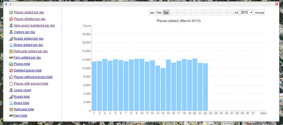
We hope, you'll find something interesting there!
Wikimapia team.
By the way, average human spends more than 6 months of his life waiting for a green traffic light.
31.12.2009
Dear Wikimapians!
We wish you a wonderful and happy New Year! It certainly will be creative and inspiring for us all. Wikimapia team has great plans for this year, starting from new history and watchlist for all actions in Wikimapia to new interesting features which we had in mind for a long time.
Let's describe the whole world!
Wikimapia team.
12.12.2009
Today we change place deletion interface. From this time you must choose reason for place deletion and it will be saved for later use (also will be shown in future releases of watchlist). Current reasons for deletion are:
There is no place marked by this outline
Non-existent place, even if it was there in the past
Planned building or road, which have not been constructed yet
Movable object or vehicle: bus, car, ferry, airplane, ship etc
A non-existing place where any event happened
Duplicate place
Place has incorrect description (propose to correct/clear information)
Place has incorrect outline (propose to correct outline)
04.12.2009
We've been promising this since the beginning, and now it happened. Today we open our Wikimapia Database through Wikimapia API. Since that day developers around the world can integrate Wikimapia Geo Data into their external applications and web sites. We provide you with free access to Wikimapia DB, collected by our contributors, with the aim to help the geographic community to use this data not only on Wikimapia site, but through any other website or application, including mobile and GIS apps. So everyone can use them everywhere.
We open Wikimapia data free for non-commercial use (as you mention the original data source, according Wikimapia TOS). We will be in close contact with developers via our discussion forum in API section, supporting them with all the required documentation and updates. Hope soon we will publish a best-practices guide for our API. Our API is still a developing stage (beta), more features will be added soon such as roads, graphic tiles use, then adding information from mobile devices to Wikimapia DB.
Find out more here http://wikimapia.org/api/. Start with registration and reading our usage rules (and applying for the key). Then go ahead - start developing your software! Your feedback and suggestions are welcome!
03.07.2009
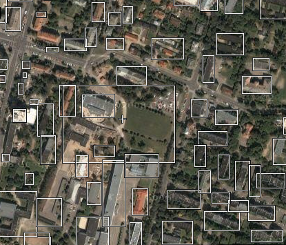
We released the new version of Wikimapia. It is the next step in Wikimapia development to make the map more readable for users. A few months after launching Wikimapia we faced the problem of rectangles' mess in populated areas. Previous version of Wikimapia with rectangles was quite unreadable by ordinary visitors, we found this out by several usability tests.
To give a visual presentation of changes here is a demonstration of Wikimapia in old version:
New Wikimapia presents this in a better way:
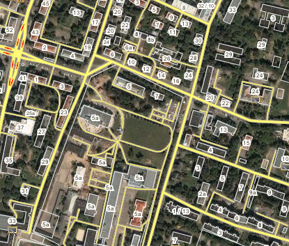

Link to this place
Old version of Wikimapia is available on the "Map type" menu as a Classic Wikimapia option.
Let's describe the whole world!
24.05.2009
This month we celebrate 3 years birthday of Wikimapia, as well as passing the creation of 10 000 000 places and 2 500 000 kilometers of roads.
We launched Wikimapia with the aim to create and maintain an interactive, editable, free, multilingual, up-to-date map of the whole world
Our long-term objectives are clear - we need to describe the whole Earth:
all places (to create places outlines, titles, descriptions, addresses, categories);
all additional mapping data (islands, coastlines, rivers, etc.);
all roads (names, special information for routing and navigation);
all transport infrastructure (railroads, ferry ways, urban transport, etc.) in a way to use it for routing and navigation, not only for use in cars, but also for pedestrians and other use in transport;
all countries and administrative borders
Not all features are finished, but we are implementing them step-by-step, here are some of them which we plan to introduce very soon:
API, then all people will be able to use geodata stored in Wikimapia;
functional history for actions in Wikimapia;
ability to add many places on one area (for example: restaurant, shop and pharmacy in the same building)
We want to thank all our users for their help.
Let’s describe the whole world!
Alexandre Koriakine and Evgeny Saveliev
Wikimapia team
